Saturday, March 28, 2009
This week has been busier than normal: I've read three books (two novels and a book on the theory of novels) for two different classes. While one novel and the theory book were (not surprisingly) for The Novel, the other was for my basic sociology course — although it has some problematic parts, I overall enjoyed this book, The Namesake. The same could be said about the book I read for the literature class, the classic French novel Madame Bovary. Next week it's two more: Out of the Salt Shaker (not sure its subject) for Evangelism, and Great Expectations (Dickens) for The Novel.
Thus no posting for a week.
Today, after classes were finished, I began a cycle trip longer than any other that I've made in Western Pennsylvania. Like several other times, I rode to Beaver, but this time I went to the Ohio line and continued into Columbiana County as far as central East Liverpool, perhaps three miles away. The roads were good today (tomorrow was the original plan), and the hills along the Ohio were minimal; the largest hills, in fact, were in East Liverpool as I climbed to see a few sites north of downtown, and along the highway when there were bridges. Quite a nice, pleasant ride.
On the way back, it was somewhat embarrassing: although my careful plan involved me returning to Beaver Falls by perhaps 7PM, I found that something was wrong with the plan, as that time was when I was crossing back into Pennsylvania. Thankfully, when I called them, a couple from church graciously agreed to drive me from a place west of Beaver, where I'd stopped about an hour after subset because darkness was making cycling dangerous. I'm wondering if the problem with my plan was that I wanted to spend more time in my state than I should have?
Only once before have I crossed a state line on a bicycle: going from Indiana to Michigan on the trip to Calvin in 2004. These two times (PA to OH and OH to PA) were rather more impressive: instead of an insignificant road in the middle of the woods, I was riding a two-lane highway along the Ohio River — okay, it's not that lovely at this point, but anything Ohio is good :-)
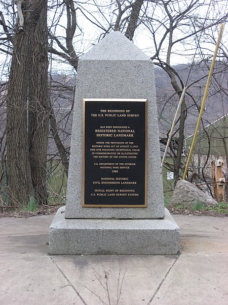
However, unlike the Indiana/Michigan line, the Ohio/Pennsylvania line here is the location of a historic site important to residents of most of the United States: the Beginning Point of the U.S. Public Land Survey. Overall, while it's a diminutive stone marker, its significance is great indeed. A National Historic Landmark (one of only 69 statewide, and one of only two rural ones in northeastern Ohio), it marks the site of the public land surveying system that was used to measure nearly all of the United States outside of the thirteen colonies; Vermont, Hawaii, and Texas have their own systems, as do parts of other states, but what happened at this site is the reason that the rest of the country is laid out as it is. Do you live in the old Northwest Territory or west of the Mississippi? Are there local roads each one mile apart? It's almost certain that your land was surveyed under the system that started here.
Thus no posting for a week.
Today, after classes were finished, I began a cycle trip longer than any other that I've made in Western Pennsylvania. Like several other times, I rode to Beaver, but this time I went to the Ohio line and continued into Columbiana County as far as central East Liverpool, perhaps three miles away. The roads were good today (tomorrow was the original plan), and the hills along the Ohio were minimal; the largest hills, in fact, were in East Liverpool as I climbed to see a few sites north of downtown, and along the highway when there were bridges. Quite a nice, pleasant ride.
On the way back, it was somewhat embarrassing: although my careful plan involved me returning to Beaver Falls by perhaps 7PM, I found that something was wrong with the plan, as that time was when I was crossing back into Pennsylvania. Thankfully, when I called them, a couple from church graciously agreed to drive me from a place west of Beaver, where I'd stopped about an hour after subset because darkness was making cycling dangerous. I'm wondering if the problem with my plan was that I wanted to spend more time in my state than I should have?
Only once before have I crossed a state line on a bicycle: going from Indiana to Michigan on the trip to Calvin in 2004. These two times (PA to OH and OH to PA) were rather more impressive: instead of an insignificant road in the middle of the woods, I was riding a two-lane highway along the Ohio River — okay, it's not that lovely at this point, but anything Ohio is good :-)
However, unlike the Indiana/Michigan line, the Ohio/Pennsylvania line here is the location of a historic site important to residents of most of the United States: the Beginning Point of the U.S. Public Land Survey. Overall, while it's a diminutive stone marker, its significance is great indeed. A National Historic Landmark (one of only 69 statewide, and one of only two rural ones in northeastern Ohio), it marks the site of the public land surveying system that was used to measure nearly all of the United States outside of the thirteen colonies; Vermont, Hawaii, and Texas have their own systems, as do parts of other states, but what happened at this site is the reason that the rest of the country is laid out as it is. Do you live in the old Northwest Territory or west of the Mississippi? Are there local roads each one mile apart? It's almost certain that your land was surveyed under the system that started here.
# posted by erudil @ 01:07

Thursday, March 19, 2009
760
How many pictures did I take on this trip? It's actually a little more than this, because I've deleted a few; but I'm amazed at how many pictures I could take in little over a week.
We returned yesterday evening after several busy days. Instead of worshipping at Salt and Light, we went with our host family to Laramie, Wyoming, to worship with the church plant there. I never imagined that I'd get to go to Wyoming! It was encouraging to meet some people there and to see the few people that I knew there.
Most of Monday we spent in downtown Denver: after having an extensive and enjoyable tour of the Capitol (we got to see both houses of the General Assembly in session), we walked all over the heart of the city. While the others preferred to visit sites along the impressive Sixteenth Street Mall (a long pedestrian mall, with no traffic on the street other than free busses), I wandered over the city photographing many historic buildings. That alone accounted for several dozen pictures :-)
How many pictures did I take on this trip? It's actually a little more than this, because I've deleted a few; but I'm amazed at how many pictures I could take in little over a week.
We returned yesterday evening after several busy days. Instead of worshipping at Salt and Light, we went with our host family to Laramie, Wyoming, to worship with the church plant there. I never imagined that I'd get to go to Wyoming! It was encouraging to meet some people there and to see the few people that I knew there.
Most of Monday we spent in downtown Denver: after having an extensive and enjoyable tour of the Capitol (we got to see both houses of the General Assembly in session), we walked all over the heart of the city. While the others preferred to visit sites along the impressive Sixteenth Street Mall (a long pedestrian mall, with no traffic on the street other than free busses), I wandered over the city photographing many historic buildings. That alone accounted for several dozen pictures :-)
# posted by erudil @ 10:54
Saturday, March 14, 2009
Yesterday, we went snowshoeing near Bear Lake, located in the east central region of the park: although we knew we wouldn't make it all the way, we decided to climb as far as we could along the Flattop Mountain Trail, which at the mountain's summit ends at the Continental Divide. Having never snowshoed before, I found it an interesting and very exciting experience, especially as the trail has extremely wide views of vast areas of countryside. Nevertheless, it was somewhat difficult: by the time we turned around (because of a time commitment), we were quite tired, and today I've felt pain in places I've never known it before. Not a surprise when engaging in a new activity.

Today, we planned to go down to the "Garden of the Gods", a large city park in Colorado Springs. However, we knew that we'd have plenty of extra time, so we agreed to take Interstate 70 west of Denver before going to the Springs. Just before the Divide, we got off onto U.S. Route 6, which goes over the Loveland Pass instead of tunnelling through it like the interstate does.
After coming down from our mountaintop experience, we went to the Springs; the Garden was quite impressive, although smaller than I had hoped. It was enjoyable, but I preferred the trip west.
Today, we planned to go down to the "Garden of the Gods", a large city park in Colorado Springs. However, we knew that we'd have plenty of extra time, so we agreed to take Interstate 70 west of Denver before going to the Springs. Just before the Divide, we got off onto U.S. Route 6, which goes over the Loveland Pass instead of tunnelling through it like the interstate does.
After coming down from our mountaintop experience, we went to the Springs; the Garden was quite impressive, although smaller than I had hoped. It was enjoyable, but I preferred the trip west.
# posted by erudil @ 23:57
Thursday, March 12, 2009
While driving into Estes Park today, we saw a herd of elk: although I've seen them before, for everyone else in my group it was the first time. For me, too, it was by far the closest. Meanwhile, as we were leaving the national park, we passed another herd, prompting the following quote from our driver:
How cute — I really want to eat one!
# posted by erudil @ 21:42
Yesterday and today have been busier than the previous days: thus no post. Yesterday was the Gem Lake hike: we went on a trail just north of Estes Park that goes as far as the small Gem Lake. This wasn't all that we did at the site: by climbing rocks near the lake, we had an amazing view of Estes Park and the surrounding countryside.


Today we went hiking along the old Fall River Road, the first highway to traverse the park. It was rather less difficult (after all, it was made for automobiles, not just hikers), but also passes along ridges with amazing views. I'd post a picture from there, too, but I've not had a chance to upload one yet.
Today we went hiking along the old Fall River Road, the first highway to traverse the park. It was rather less difficult (after all, it was made for automobiles, not just hikers), but also passes along ridges with amazing views. I'd post a picture from there, too, but I've not had a chance to upload one yet.
# posted by erudil @ 21:14
Wednesday, March 11, 2009
Today we went through the canyon of the South St. Vrain Creek, west of Longmont — I had been through it before, on the way to Covenant Heights, but the others hadn't, of course. Weather was rather different from yesterday: then we carried our long-sleeved shirts in the backpacks, while today we wore them under our coats. Moreover, some roads — including State Highway 7 in the canyon — weren't the best, with some snow and ice; we nearly we stuck on the side of the road at one point, due simply to significant amounts of snow and ice. On the other hand, the winter improves the canyon: it's impressive enough in early July, but it's wonderful in early March.
After the canyon and heading north through Allenspark and Estes Park, we ventured into the national park for the first time. I was surprised to see that a few miles of the easternmost part of Trail Ridge Road (the main trans-park highway) were open, despite the weather; but they were, so we went there. We did very little hiking, due to the wind: it was fierce enough that we couldn't hear when standing next to each other, and I feared frostbite if we turned around much later than we actually did. As it is, no frostbite or any other damage done :-)
After the canyon and heading north through Allenspark and Estes Park, we ventured into the national park for the first time. I was surprised to see that a few miles of the easternmost part of Trail Ridge Road (the main trans-park highway) were open, despite the weather; but they were, so we went there. We did very little hiking, due to the wind: it was fierce enough that we couldn't hear when standing next to each other, and I feared frostbite if we turned around much later than we actually did. As it is, no frostbite or any other damage done :-)
# posted by erudil @ 01:26
Monday, March 09, 2009
Back in January, some of us from Eastvale began considering a trip over spring break — but where would we go? Eventually, we decided to try to go rather long distance: to Colorado, to go hiking. Ultimately, four of us left Pittsburgh by Greyhound last Friday night, and after a long drive we're now north of Denver!
We had some interesting problems along the way — at St. Louis the bus was more than doubly-booked, so we had to wait for them to find another bus: delay of a little more than two hours. At Kansas City, the bus had mechanical problems: thankfully not much of a delay, but still...Ultimately, we reached Denver at 12:30 AM yesterday, a little more than an hour late.
The only reason we're able to be staying out here is help from people in two different RP churches: Westminster RP in the northern suburbs of Denver, and Salt and Light in Longmont north of Denver. We've been allowed to borrow a truck by one of the Westminster members! After we reached Denver, we stayed with a family in Aurora (just southeast of Denver), who picked us up at the bus station; and now we're staying with another family on the southwestern side of Longmont. We worshipped at Westminster yesterday morning and with Salt and Light last night.
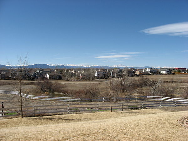
Yesterday, we got to see more than we expected: it was such a clear day that we could see Longs Peak (the highest point in Rocky Mountain National Park) well north of Denver, all the way south to Pikes Peak (west of Colorado Springs), all from the same point!
Today, we don't look to be doing anything strenuous; it's mostly going to be a day of exploring the good roads and seeing where we want to go in future days. In 2006, I was at the Midwest Presbytery's family conference at Covenant Heights (below Longs Peak, just west of Longmont), but none of the others in my group have ever crossed the Mississippi before now. Therefore, we're starting by taking the highway past Covenant Heights, since we know that it's clear and safe; and hopefully going other places a little bit to the south. We're looking forward to this week :-)
# posted by erudil @ 12:08
Friday, March 06, 2009
What do you think of when you hear the word "supreme"? The five of us on my floor discussed this question earlier this morning. Two of us — including the one who brought up the question — think of pizza, while the other three — including me — think of nine people in black robes.
# posted by erudil @ 10:32
Monday, March 02, 2009

